Heavy Rain and Storms Sweep Through Chicagoland, Causing Ground Stops and Flood Risk
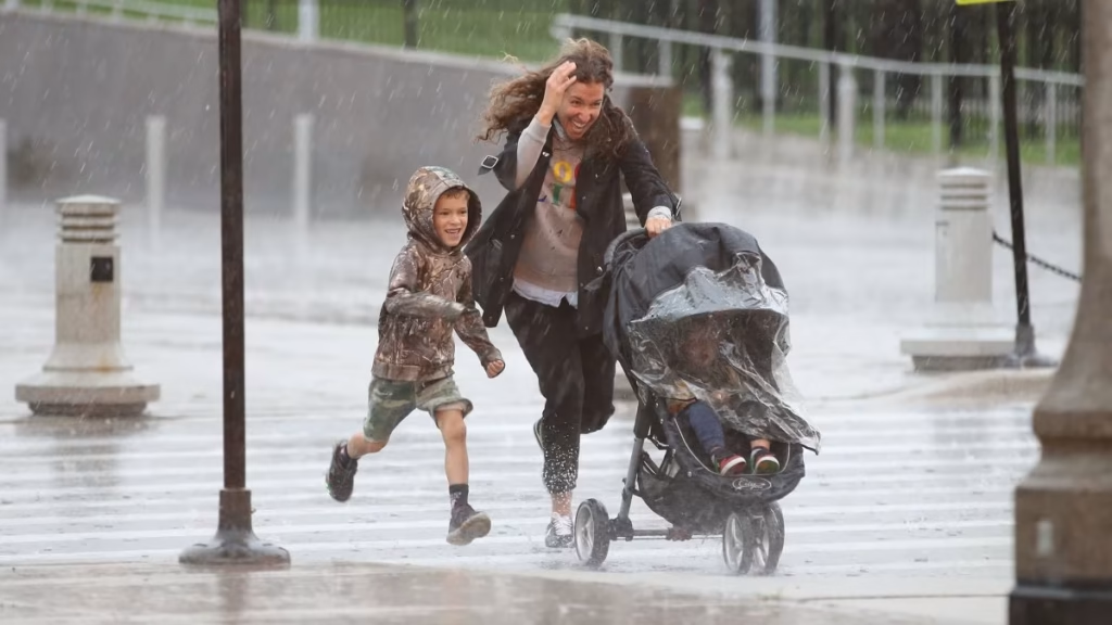
Heavy rain and thunderstorms moved through the Chicago area early Thursday morning, prompting federal aviation officials to issue ground stops at both major airports and creating hazardous conditions for the morning commute. The National Weather Service warned that torrential downpours could lead to localized flooding, with some areas potentially seeing rainfall rates of up to 4.5 inches per hour.
The Federal Aviation Administration issued a ground stop for departures at O’Hare International Airport through 7:15 a.m. and at Midway Airport through 6:45 a.m., according to the agency.
Live Doppler radar showed a cluster of showers and storms producing lightning and thunder across Lee, Ogle, Kane, DeKalb, and Cook counties during the early morning hours. The heaviest showers and thunderstorms were expected north of Interstate 80.
The rain was already causing problems on roadways for the rush hour commute. As of 5:30 a.m., three left lanes were blocked on Interstate 88 at the Meyers Toll Plaza on the border of Downers Grove and Oak Brook due to a serious crash.
Rain was likely a factor in the crash, NBC 5 traffic reporter Kye Martin said. A huge backup was reported heading in from Highland into Meyers.
NBC 5 Storm Team Meteorologist Iisha Scott described the weather pattern as repetitive. Morning showers and storms once again, Scott said. Sounding like a broken record here.
Showers and storms were expected to continue through the late morning. By about 11 a.m., conditions were expected to dry out under mostly cloudy skies.
Weekend Flood Threat
The rainy conditions come as a frontal boundary remains stalled across the region, with showers and storms riding along it. The National Weather Service said additional episodes of showers and storms are expected through the weekend.
While Friday morning will remain dry, another wave of showers will move in about 5 p.m. Rain will continue overnight into Saturday, with heavy downpours and storms into the morning.
If you have got Saturday morning plans, they are not looking good at all, Scott said. These storms will be putting down very heavy rain, with the potential for flooding.
Scattered rain will continue at times through the daytime hours Saturday, and then area-wide Saturday night and Sunday. The National Weather Service warned that repeated downpours may lead to localized flooding.
According to the Weather Channel, a slow-moving frontal boundary is drifting across the Midwest and Central Plains, clashing with the outer rim of a stubborn heat dome over the South. This has allowed the front to stall out, resulting in days of flooding over the same areas.
Event Disruptions
The weekend forecast could create challenges for several major outdoor events in Chicago. Riot Fest is scheduled for Friday through Sunday at Douglass Park, and festivalgoers could encounter showers and thunderstorms, particularly on Saturday.
The Chicago Bears are scheduled to host the Minnesota Vikings at noon Sunday at Soldier Field, with lingering showers possible depending on how quickly the weather system moves through. The Chicago White Sox are set to host the Detroit Tigers from Thursday through Sunday at Rate Field, with rain chances affecting portions of the homestand.
This wet pattern follows an unusually rainy summer for Chicago. The city recorded 15.38 inches of rain between June 1 and August 31, which was 3.32 inches above the seasonal average.
Temperatures are expected to remain mostly in the 70s through the weekend, with a brief warm-up toward 80 degrees on Saturday. Cooler air is expected to arrive Saturday night and Sunday, with temperatures possibly falling into the 60s for the first time this season by Monday or Tuesday.
nn
Image Via: NBC Chicago
Related News
Hilary Duff Extends The Lucky Me Tour With Pittsburgh Arena Show Set for October 2027

Netflix Stock Falls in September as Analysts Point to YouTube Competition and Weak Engagement
Morgan Stanley Report Projects Hyperscaler AI Spending to Surpass $2 Trillion as Free Cash Flow Declines
Iran Downplays Direct Talks With US as Gulf Leaders Meet Trump on War Strategy

Jimmy Kimmel Criticizes Trump Press Ban With Remark on Melania Trump’s Separate Bedroom